By John Coleman GLIFWC Environmental Section Leader
Following the failure of a $50 million grant from the Michigan Economic Development Corporation (MEDC) to Highland Copper to make it into the state budget for the proposed Copperwood Mine, site development has slowed but continues to move ahead. Tapping existing funds, Highland Copper is creating wetlands at the Gogebic County site as part of the project’s wetland and stream mitigation program. The MEDC grant was slated to assist in developing the Copperwood project on the shores of Lake Superior but remains contingent on Highland first raising an additional $150 million of development funds; should Highland generate the required base funding by December 2025, Michigan officials may again offer the $50 million grant. In another development, GLIFWC released a tailings basin dam failure report last June.
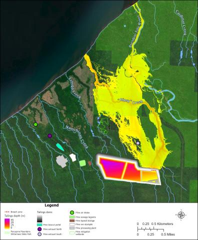
The document details modeling of the spread of tailings should any of the proposed tailings basin dams fail. Since there had been no publicly available analysis of the consequences of a dam failure, GLIFWC analyzed the effects of an accidental tailings release. The failure modeling found that tailings released by dam failure could reach Anishnaabeg Gichigami in less than an hour, could inundate the Presque Isle River in less than 1.5 hours, and could affect the underground mine entrance and other mine structures. Tailings flowed into the Porcupine Mountains Wilderness State Park in most modeled dam breaches. The tailings floods could reach up to 46 feet high in parts of the flooded areas.
These results suggest unacceptable consequences for downstream lands and waters, including Anishnaabeg Gichigami and the Presque Isle River, and for mine safety. The analysis did not evaluate the probability of a dam breach, only the spread of tailings across the landscape should a dam fail. The report, and a letter to the Michigan Department of Environment, Great Lakes, and Energy (EGLE) asked that further dam safety and water- way impact analyses be conducted when final dam design has been completed. Learn more at GLIFWC’s report archive (glifwc.org/reports).
The analysis describes the likely inundation of rivers, streams and the Lake Superior shore in the event of a potential tailings dam failure. Watch a video of tailings spread from a breach at: tinyurl.com/3j8srde6 Potential dam inundation map for failure of the north dam of the eastern cell of the proposed Copperwood tailings facility. Downstream tailings depths represent the maximum depth five hours after breach. We did not model tailings flows in Anishinaabeg Gichigami
Fig.1 Potential dam inundation map for failure of the north dam of the eastern cell of the proposed Copperwood tailings facility. Downstream tailings depths represent the maximum depth five hours after breach. We did not model tailings flows in Anishinaabeg Gichigami.