Let's eat walleye safely
The return of extended sunshine after a long cold winter means spring ogaa (walleye) spearing season is on the horizon. As families begin to prepare for spring harvest activities, food safety is a top priority. GLIFWC’s Mercury Maps can help you and your family make informed decisions about where to harvest ogaa and how much is safe to eat.
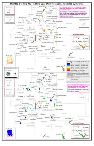
Like all fish species, ogaawag contain mercury, a contaminant that can have negative health impacts, particularly for developing fetuses and young children, if exposure becomes too high. If you are pregnant or nursing, are able to become pregnant, or are under 15 years of age, you are considered a sensitive population.
GLIFWC’s Mercury Maps provide fish consumption guidance for over 350 lakes across the Ceded Territories of Minnesota, Wisconsin, and Michigan. These maps detail the safe number of meals you can eat per month from each lake. To reduce mercury exposure, choose lakes with lower levels of mercury. Ogaa less than 20 inches and other species of fish lower on the food chain tend to have lower mercury levels. Mercury Maps are available online at tinyurl.com/yc6m4444 at tribal registrations stations and other GLIFWC outreach events throughout the year.
Treaty rights support tribal members’ ability to hunt, fish and gather off-reservation to provide their families and communities with high quality foods. Spring spearing and netting are an integral part of the Anishinaabe bimaadiziwin (tribal lifeway), and each harvest reaffirms tribal members’ treaty rights. We wish everyone a safe and abundant spring harvest season! —C. Ackley