Manoomin (wild rice) harvest regulations and information.
The following provisions apply to manoomin harvesting, in addition to general harvest regulations, in the 1837 and 1842 Ceded Territories in Wisconsin and Minnesota.
This page does not detail harvest regulations in their entirety. Check with your Tribe for their full code of regulations which may have more restrictive regulations.
Tribal wild rice harvest permits are required for off-reservation wild rice harvest in Wisconsin. The dates that a regulated lake is open for harvesting will be posted at the access points to the lake.
Permits: You must carry your manoomin/ricing permit from NAGFA and your tribal ID with you when ricing off-reservation. Contact your tribal registration clerk or GLIFWC to obtain an off-reservation ricing permit.
Ricing Sticks: You must use smooth, rounded, cedar rods or sticks, no longer than 38 inches in length to harvest wild rice (note: "binding" the rice stalks is not permitted).
Boats: Boats can be no longer than 17 feet; and no wider than 38 inches. The gunwales of the boat cannot be modified to capture rice outside of the boat. Boats can only be propelled with a push pole or canoe paddle.
Hours: Wild rice can only be harvested between the hours of 10:00 am and sunset on all public rice waters.
Date-Regulated Lakes: No ricing is allowed on off-reservation date-regulated lakes, except for the days they have been named open by the tribal ricing authority (listed on the GLIFWC website).
Tribal wild rice harvest permits are required for off-reservation wild rice harvest in Minnesota.
Permits: You must carry your permit and your tribal ID with you when ricing off-reservation. Contact your tribal conservation department or GLIFWC to obtain an off-reservation ricing permit.
Ricing Sticks: You must use smooth, rounded, cedar rods or sticks, no longer than 32 inches in length to harvest wild rice.
Boats: Boats can be no longer than 18 feet; and no wider than 38 inches. The gunwales of the boat cannot be modified to capture rice outside of the boat. Boats can only be propelled with a push pole or canoe paddle.
Hours: Wild rice can only be harvested between the hours of 9:00 am and sunset on all public waters.
Open Season: No member shall harvest wild rice in any body of water, except during the time(s) that such body of water is posted as open by the Mille Lacs Band Wild Rice Authority. Posting a body of water as open will be done on the shores of, and at places of access to, the wild rice waters.
The estimates of rice abundance on Wisconsin date-regulated waters are compiled from remote sensing, air, and ground surveys. Preliminary maps and survey information derived from satellite data and aerial flights are provided for the current harvest season. Opening dates for date-regulated waters will be posted as we receive them from Tribal rice chiefs. If the water you are interested in is not on the list of date-regulated waters, you may harvest it whenever the rice is ripe. (All other ricing regulations still apply.)
WI Date Regulated Manoomin Waters Aerial Photos and Remote Sensing
NOTE: click on a column heading to sort table.It is important to note that even where rice plants appear to be relatively abundant, seed production can be poor due to disease or other factors. In addition, heavy rain events and other factors can change the status of the beds after surveys have been conducted. You are encouraged to use this information as an initial guide, and conduct your own scouting trips to the waters you are considering harvesting.
Best wishes for a great season!
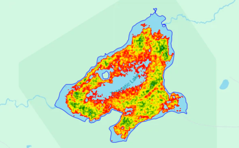
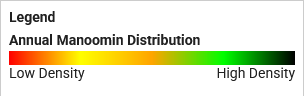
Shown below is a remote sensing map of manoomin abundance and distribution from a previous year at Totagatic Lake, Bayfield County. These maps are derived from satellite imagery taken throughout the growing season and modeled to isolate manoomin annual growth. The darker green pixels in the image indicate a higher density of manoomin. The red pixels indicate a lower density of manoomin.
We welcome questions and feedback. Please contact:
Austen Hilding, Wetland Ecologist
Kathy Smith, Manoomin Ganawandang "she who takes care of the rice"
Miles Falck, Wildlife Section Leader